
Tierra Data identifies and maps natural resources values sufficient to support environmental impact assessments. Our biologists are skilled in the fields of botany, restoration ecology, rangeland management, wildlife ecology, fire ecology, and wetland ecology.
Services
– Land trend and ecological trend monitoring
– Sensitive plants and wildlife
– Biological baseline studies
– Wetland delineations
– Mitigation monitoring
– Fire mapping
– Fire emergency stabilization and rehabilitation monitoring
– Fire treatment effectiveness monitoring
– Fire effects
– Certification in Veg Camp (Sawyer/Keeler-Wolf) procedures (training through California Native Plant Society/CDFG
– Quantitative Floristics
– International vegetation classification and mapping standards
KEY PROJECT
Biological Resources Surveys for Naval Base Coronado’s Naval Outlying Landing Field Imperial Beach, California
Tierra Data provided the U.S. Navy with a comprehensive inventory of natural resources at Naval Outlying Landing Field Imperial Beach, a practice field for helicopter operations, located in the Tijuana River Valley south of the Silver Strand. To achieve this a wide range of surveys were conducted on approximately 1,200 acres. These included botanical (vegetation mapping, rare plant & invasive plants), wildlife (invertebrates, fish, herpetofauna, birds, mammals), sensitive wildlife (fairy shrimp, secretive marsh birds, least Bell’s vireo, southwestern willow flycatcher) and a wetlands delineation.
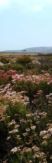
Photo © Tierra Data
Illustration © Christine Elder